![](/images/other/stat-length.png)
![Tocht Stappen Le Mage - [Itinéraire] Le Buisson - Photo](https://media.geolcdn.com/t/1900/400/ext.pjpeg?maxdim=2&url=https%3A%2F%2Fstatic1.geolcdn.com%2Fsiteimages%2Fupload%2Ffiles%2F1553511878bg_sport_marche.png)
[Itinéraire] Le Buisson
ODDAD78
Gebruiker
![Lengte](/images/other/stat-length.png)
![Max. hoogte](https://static1.geolcdn.com/siteimages/upload/files/1508320355ic_sort_altitude_max_24dp.png)
![Positief hoogteverschil](https://static1.geolcdn.com/siteimages/upload/files/1508320355ic_sort_den_pos_24dp.png)
![Km-Effort](/images/other/stat-length.png)
![Min. hoogte](https://static1.geolcdn.com/siteimages/upload/files/1508320355ic_sort_altitude_min_24dp.png)
![Negatief hoogteverschil](https://static1.geolcdn.com/siteimages/upload/files/1508320355ic_sort_den_neg_24dp.png)
![Boucle](https://static1.geolcdn.com/siteimages/upload/files/16400158638029165_repeat_loop_refresh_sync_direction_icon.png)
![Stappen](https://static1.geolcdn.com/sitytour/trail-icons/101.png)
3h34
Moeilijkheid : Moeilijk
![Mountainbike](https://static1.geolcdn.com/sitytour/trail-icons/202.png)
1h05
Moeilijkheid : Gemakkelijk
![Hybride fiets](https://static1.geolcdn.com/sitytour/trail-icons/203.png)
--
Moeilijkheid : Gemakkelijk
![Elektrische fiets](https://static1.geolcdn.com/sitytour/trail-icons/205.png)
0m
Moeilijkheid : Heel gemakkelijk
![Scan deze QR-code om de tocht te openen in de SityTrail-applicatie](https://capi.geolives.com/qq0zvz2zws4bq2lad0pu/sitytour/trails/3790920/qr.png?size=200)
Gratisgps-wandelapplicatie
Over ons
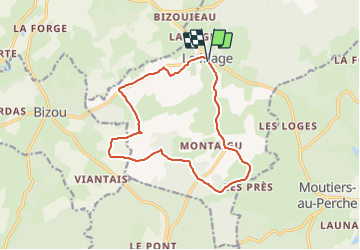
Tocht Stappen van 13 km beschikbaar op Normandië, Orne, Le Mage. Deze tocht wordt voorgesteld door ODDAD78.
Beschrijving
Départ : Le Mage Arrivée : Le Mage Balisage : PR Communes : 1. Le Mage 2. Bizou
3. Moutiers-au-Perche
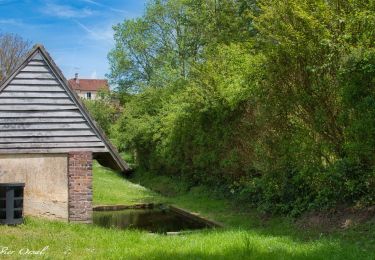
Quitter le parking en se dirigeant vers le centre-bourg. Après l'église, prendre tout de suite à gauche : descendre et suivre le chemin qui mène au lavoir. Au lavoir, poursuivre tout droit jusquà rejoindre la départementale, que l'on emprunte plusieurs mètres.
1. Tourner à gauche et suivre cette toute petite route : prendre la 1ère à droite et poursuivre jusqu'à tourner à droite à nouveau (cela monte une peu) pour rejoindre la route.
2. A la départementale, prendre à gauche et la suivre (rester prudent). Laisser Les Haies Quartier sur droite, puis plus loin, tourner à gauche. Passer par le hameau du Mesnil Pot et poursuivre tout droit.
3. Dans les bois bifurquer à droite et suivre le chemin jusqu'à rejoindre une route.
4. Puis prendre à gauche (on récupère ici un autre circuit : les sables du Perche, au départ de Bizou),
jusqu'à rejoindre un champs : tourner à gauche et poursuivre tout droit jusqu'à longer à nouveau un
bois par la droite (le circuit des sables du Perche, lui, aura été laissé avant).
5. Prendre à droite et poursuivre dans la forêt : superbe chemins de trognes !)
6. Traverser la route et prendre presque en face, sur gauche, le chemin qui se poursuit et rejoindre le
lieu-dit "L'Allemandière". Poursuivre tout droit jusqu'à la route. A la route, tourner à gauche, puis poursuivre à gauche. Passer l'Auberdière (sur droite), puis Les Chaintres (sur gauches) et au bout de la route, prendre à droite. Poursuivre tout droit jusqu'au Pont Riboult.
7. Laisser un autre circuit de randonnée partir sur gauche (circuit du nom du lieu-dit, le Pont Riboult) et poursuivre à droite jusqu'à rejoindre le parking.
(Pas à pas : Rando-Perche)
Plaatsbepaling
Opmerkingen
Wandeltochten in de omgeving
![Tocht Stappen Longny les Villages - [Itinéraire] La Brisardière - Photo](https://media.geolcdn.com/t/375/260/19108d03-3d8a-43b4-b05b-172408edde68.jpeg&format=jpg&maxdim=2)
![Stappen Stappen](https://static1.geolcdn.com/sitytour/trail-icons/101.png)
Stappen
![](/images/other/stat-length.png)
![](https://static1.geolcdn.com/siteimages/upload/files/16400158638029165_repeat_loop_refresh_sync_direction_icon.png)
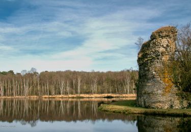
![Tocht Stappen Bizou - [Itinéraire] Les sables du Perche - Photo](https://media.geolcdn.com/t/375/260/6b586e88-fad3-40df-be07-9b2a61186b9b.jpeg&format=jpg&maxdim=2)
![Stappen Stappen](https://static1.geolcdn.com/sitytour/trail-icons/101.png)
Stappen
![](/images/other/stat-length.png)
![](https://static1.geolcdn.com/siteimages/upload/files/16400158638029165_repeat_loop_refresh_sync_direction_icon.png)
![Tocht Stappen Moutiers-au-Perche - 2023-05-20_10h18m41_Moutiers-au-Perche Rando de Samedi - Photo](https://media.geolcdn.com/t/375/260/dd304cf5-1fa7-4625-9960-289d50411375.jpg&format=jpg&maxdim=2)
![Stappen Stappen](https://static1.geolcdn.com/sitytour/trail-icons/101.png)
Stappen
![](/images/other/stat-length.png)
![](https://static1.geolcdn.com/siteimages/upload/files/16400158638029165_repeat_loop_refresh_sync_direction_icon.png)
![Tocht Te voet Moutiers-au-Perche - Perche authentique - Photo](https://media.geolcdn.com/t/375/260/1c5fa599-8a3f-4902-99d5-149fc7bd1ba4.jpeg&format=jpg&maxdim=2)
![Te voet Te voet](https://static1.geolcdn.com/sitytour/trail-icons/100.png)
Te voet
![](/images/other/stat-length.png)
![](https://static1.geolcdn.com/siteimages/upload/files/16400158638029165_repeat_loop_refresh_sync_direction_icon.png)
![Tocht Stappen Le Mage - Le Mage - Longny-au-Perche (Longny les Villages) 11 km - Photo](https://media.geolcdn.com/t/375/260/7da85c06-6bc5-432c-afb8-5444ae0d01ad.jpg&format=jpg&maxdim=2)
![Stappen Stappen](https://static1.geolcdn.com/sitytour/trail-icons/101.png)
Stappen
![](/images/other/stat-length.png)
![](https://static1.geolcdn.com/siteimages/upload/files/16400158638029165_repeat_loop_refresh_sync_direction_icon.png)
![Tocht Stappen Le Mage - Le Mage - Moutiers-au-Perche 9,2 km - Photo](https://media.geolcdn.com/t/375/260/2d6a74b1-d9ee-4f0d-9acb-9c00ceb2d8ab.jpg&format=jpg&maxdim=2)
![Stappen Stappen](https://static1.geolcdn.com/sitytour/trail-icons/101.png)
Stappen
![](/images/other/stat-length.png)
![](https://static1.geolcdn.com/siteimages/upload/files/16400158638029165_repeat_loop_refresh_sync_direction_icon.png)
![Tocht Stappen Longny les Villages - Longny-au-Perche (Longny-les-Villages) - Moutiers-au-Perche 13 km - Photo](https://media.geolcdn.com/t/375/260/994a1e71-8c6d-4d56-88cb-a3f14cc14c65.jpg&format=jpg&maxdim=2)
![Stappen Stappen](https://static1.geolcdn.com/sitytour/trail-icons/101.png)
Stappen
![](/images/other/stat-length.png)
![](https://static1.geolcdn.com/siteimages/upload/files/16400158638029165_repeat_loop_refresh_sync_direction_icon.png)
![Tocht Stappen Longny les Villages - Longny-au-Perche (Longny-les-Villages) - Tourouvre 22 km - Photo](https://media.geolcdn.com/t/375/260/f6a882c6-7265-4c4e-81b2-b739ea6f09f8.jpg&format=jpg&maxdim=2)
![Stappen Stappen](https://static1.geolcdn.com/sitytour/trail-icons/101.png)
Stappen
![](/images/other/stat-length.png)
![](https://static1.geolcdn.com/siteimages/upload/files/16400158638029165_repeat_loop_refresh_sync_direction_icon.png)
![Tocht Stappen Bizou - Bizou 10.1 Km - Photo](https://media.geolcdn.com/t/375/260/4d9e3be8-2feb-4dcb-8c0c-693e0d367f80.jpeg&format=jpg&maxdim=2)
![Stappen Stappen](https://static1.geolcdn.com/sitytour/trail-icons/101.png)